An expedition governed by the Niña, name given to the cooling down of the surface water of the central pacific ocean, which has generated a monstrous high pressure cell above our heads for three months.
Notwithstanding this apparently adverse phenomenon, the Polish and the Czechian teams succeeded in bringing home not less than twenty national records, on Christmas day we could set a new world distance record of 1634km on FAI triangle at our first attempt and under meteorological conditions from weak to horrible. Plus a splendid 2000km declared for Sebastian Kawa flying together with Bruce Cooper, the British 2000km badge N°1 for John Williams, a 1000km badge for Roy Wilson and the French N°1 badge 1500km for me.
We never flew so much, 315 hours in the Nimbus during 54 flying days in 75 days of presence, and 735 hours for all the gliders of our group. Because two gliders were not self launchers, the local gliding club was financially very happy with so many and long tows and outlanding air retrieves. It has been a great opportunity for the local best pilots to fly our three two-seaters and efficiently improve their wave flying techniques. We shall strongly continue in this way and I shall feel fully satisfied only when we'll see a 1000km flown by pilots of Bariloche Gliding club.
The contract has been fulfilled, we start again nest November!
The genesis of this record of the world deserves as much interest as the narration of the flight itself, because this flight is actually a fast reaction against what my British companions considered in diplomatic language an "erroneous interpretation” of a NOTAM.
It is necessary to recall that before a foreigner can fly in Argentina, he needs an authorization delivered by ANAC (National Administration of the Civil aviation), an administration freshly created last July by donation of equipment and staff from the Air Force (Fuerza Aerea).
Once authorizations for all pilots have been obtained, the always young (83 and regular flyer) and irreplaceable president of the Argentinean Aero-Club (CADEA) Lito Fentanes works obtaining clearances to fly in any class of airspace above FL 195, a condition which is absolutely indispensable to be able to safely overfly the desert pampa or very high places (some rocks are at FL 220). In a first message dated November 16th, the central regional director allowed flying above FL 195 under some conditions subject to carrying specified equipment (all achieved) and after ATC clearance depending on the traffic. Unfortunately, this derogation is accompanied by a geographical limitation between the latitudes 38° and 41°24', and between the longitude 70°30' and the Chilean border. This means that we can fly only to the north since the TMA of Bariloche ends at 41°43'! At the first attempt of flight towards El Maiten, located 100 km south, the ATC denied the take-off on the basis of this message. In spite of one visit to the TWR, they confirmed the non approval of FPL's outside of the limits specified in the NOTAM.
There was a new intervention from Lito Fentanes, this time at the highest level, the general director of ANAC, in order to get an extension of what Lito called the "box" (cajon). The final version of November 20th says : « GLIDER ACTIVITY WILL TAKE PLACE OVER THE ANDES FROM NOV-22-2010, UNTIL JAN 26-2011, DURING DAYLIGHT, COVERAGE AREA BETWEEN PARALLELS 35°00’S AND 50°00’S AND MERIDIAN 070°00’W AND THE BOUNDARY WITH CHILEAN REPUBLIC, FROM GND UNTIL FL 280. THE GLIDERS SHALL MAINTAIN PERMANENT RADIOELECTRICAL CONTACT WITH THE APPROPRIATE ATC AND TRANSPONDER ON MODE A AND C.”
New discussion with the chief of the controllers, who admits that this decision is ridiculous since for example the limitation to 50°S won't allow us to file a FPL for El Calafate situated to 50°16'S, i.e. 30km south of the 50th parallel, which also our turn point for the 2.000 km out and return to the south, and the only landable airstrip within 200 km! Furthermore, the limitation to 70°W prohibits any FAI triangle of more than 1.500 km since it is necessary to go around 68°W. Faced with this situation and the position of our ATC’s, we (John Williams, Roy Wilson, Bruce Cooper and myself) then decided to abandon the idea of the triangle and modified our tasks southbound to stay within the latitude 50°S.
The German surprise of December 8th
December 15th, FAI publishes Klaus Ohlmann’s claim for a world record, distance on triangle of 1.600 km flown December 8th, clearly outside of the area specified in the NOTAM by 113 km. One can easily imagine our reaction, and I immediately asked FAVAV (Argentinean Federation) what was their position about the validity of such a flight since, for the simple mind that I am, a NOTAM is law.
At our immense surprise, they officially answered on December 20th that "the area defined in the NOTAM 4274 don't exclude any other area, nor is a box out of which one cannot fly. In addition, if you can get a clearance from an ATC to fly outside of the area established in the NOTAM, you can do it”.
This clearly meant that the Germans had already agreed with the FAVAV on the merely informative value of this NOTAM, although the clearance until FL 280 had to be enforced. It was a pity that they had not informed us. We had the feeling of having been tricked and the best answer to this act was to beat this same record while using the same methods.
A very special Christmas Eve
My programme for the day following the receipt of this letter had already been determined : attempt of 2.000km badge, solo. Wake up at 3h30 for 12 hours of battle against more of 100 km/h of wind above 1/8 of uncertain fractos ending during the last 500 km by a magnificent blue sky. Since the 2.000 km could not be achieved, better stop at the first out and return of 1.000 km and go working on a new world record triangle.
With Bruce Cooper, we sacrifice the beautiful day of December 23rd to update the data base of the emergency landing strips on the pampa. The following day December 24th, I repeated my attempt of badge 2.000 km solo. The preceding evening, the glider was modified to fly comfortably solo, that is to say removal of the tail lead (14 kg) and installation of the cabin separator (my own invention) permitting me have access to all the accessories that are normally the duty of the rear seat: satellite telephone, snack, bible, pee bags, etc… (photo 13). Wake up again at 3h30 under a light drizzle up to the parking but fortunately not on the runway, just in time to watch John Williams (electric Antares) taking off at 5h30 local. The conditions were again not good enough for me to complete the task, so I decided to quit at the end of the first 1.000 km and 8 hours of a tricky flight. John landed at 9 a.m. and went for a rest.
December 24th, all the members of the expedition are at home for the Christmas Eve party and the excellent Malbec Fond de Cave Reserve 2006 is helping towards the general optimism. We therefore decide to file a FPL for the following day, by fax to Bariloche’s ARO, for this famous world record FAI triangle of 1.621 km, while hoping that the employee on duty at 22h on Christmas eve had something else to think about that to verify the NOTAM 4274. Telephone call at 22h30 and, oh miracle, he confirms that the FPL is approved! John, Bruce and I greet our guests around 23h00 and the alarm clock rings again at 3h30 on Christmas day. Telling you that I slept well would be a lie, same for Bruce. The sky is covered, no star, no moon (bizarre, wasn’t it full yesterday?), the trees do move, is it cool. And the moon? The disk????? let place to a black stain surrounded with a brownish crown, it was the eclipse of the century! But we were too much absorbed by the enormous task that we set and we didn't give enough attention to it. I especially believe that our brain cells were still in lethargy, helped by the remaining vapours of Malbec.
An incredible accumulation of mistakes
At 3h30 a.m., a glance to the weather maps and the IR satellite seems to indicates a strong southwest wind, more than 100 km/h in the half south. I am afraid that the second big leg of the triangle, the one of 474 km completely above the desert pampa, above an unknown and totally uninhabited area, with only three landable strips, is too difficult with such a headwind. At 4 a.m., I prepare the same task but in the reverse direction, anti-clockwise. These twenty minutes lost to prepare this task and to load the memory cards will cost me a world record among the three that were to play for. The most comical in this history is that I shall actually declare the original task (clockwise) in the two flight recorders (fortunately twice the same mistake), while believing to have loaded the new one (counter clockwise), generating an enormous confusion when crossing the start line, upside-down track twice without hearing the characteristic acoustic signal. It is whereas I understood that we had to turn the task in the opposite direction!
But even more incredible, if I had loaded the new task, we could never have completed the triangle because there was not a breath of wind north of Bariloche in the evening. At such a point that John Williams, who was closing a 2.000 km (British badge N°1), has been forced to start the engine after crossing the finish line 50km North of Bariloche. But we shall know that only in the last twenty minutes of the flight.
In brief, I need to admit that three wake up’s at 3.30 a.m. in five days is too much for me, I don't have the age of my competitors. You may tell me: but Bruce was there, he is 15 years younger! That’s true, but he did not yet fully recovered from his indisposition, and he is especially allergic to the sector photo page of my 20 year old Zander SR (me as well but the display of the wind is so good!) and two wrong crossings were needed to understand the mistake.
Finally a little bit of pleasure
I don't like much to narrate a flight, but this one is too exceptional to be forgotten, there are too many teachings to be divulged. In a big triangle, opposite to the out and return and to the yo-yo, one never flies above the same place, the conditions are completely different on each of the three legs, it is necessary to continuously invent route strategies and flying tactics. It is indeed the king of the tasks, together with the straight distance.
Therefore takeoff at 6h03 local (09h03 UTC), 30 minutes after the official dawn. Engine until the usual wave entry point which is also our start point, where we meet John Williams who, although airborne 30 minutes before us, is still there because considering the 20 minutes capacity of the batteries, he stops the engine three minutes after take off at 300 m QFE on the ridge and climbs the stairs smoothly one by one. Excellent idea since he will need his engine to return back home in the evening after crossing the finish line.
The wave is weak (2-3 m/s) the wind is 80 km/h at 4.000 m, but especially very southwest, 220-230°. No matter, we nevertheless start. The sky is divided into two parts: South to Southeast is 6 octas wave bars of strato-cumuli (Sc) with bases around 3.000 m and tops between 4.000 and 5.000 m, Northbound is blue with very few scattered fractos.
The sun is rising on a sinister grey layer of Sc turning to a vivid pink while filling us of joy.
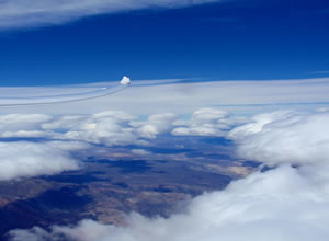
The west is as usual totally covered but fortunately the altitude of the top is low, what will allow us to overfly the first turn point above the clouds without major worry. I even take the time to make a photo.
Indeed, in this type of triangle and in order to maintain the external turn point (the one to the East) in a hilly area still generating waves, it is necessary to move the two other points as far as possible toward the west, therefore necessarily above a dead and/or covered area inside the Andes, usually in Chile. Flying from the last wave climb to the first turn point (at the Chilean border), about fifty kilometres, is a merely ballistic flight achieved at a speed permitting to come back and catch the last wave at a safe altitude. The price to pay is at least 2.000 m.
Then came the first bad surprise, with the ATC. Convinced that Bariloche had transmitted our flight plan to Ezeiza (FIR Buenos Aires), I request a clearance for FL 230 inside Chapelco TMA. That should not be a problem since there is no traffic at all in this area, in particular at 7 a.m. on Christmas day! Hey well no, not today. First of all Bariloche didn't transmit the FPL and the kind lady is not very happy, it is necessary to restart from scratch. Fortunately the plan is approved again but only until FL 195. I eventually ask to apply the NOTAM 4274 that allows until FL280, while hoping secretly that she won't understand the geographical limitation of longitude 70° in relation to the declared point: she didn't even know about the NOTAM! After some minutes of waiting, her chief answers us baldly that since the NOTAM also foresees that it is necessary to maintain the communication with the ATC, he estimates that there is a risk to lose this communication and refuses to allow more than FL 195. Useless to get excited, we will be happy with FL 195, the situation is not justifying an infringement because the transponder is ON and responds (probably Chilean radar).
From a gliding point of view, the situation is far to be brilliant. The usual energy roads are very weak, the Vz netto is around 1 m/s, not sufficient to continue cruising and it is necessary to stop for climbing at the entry of the Bariloche TMA in the only acceptable climb in a radius of 100 km, average 2 m/s, a misery!
New surprise: Ezeiza did not transmit our flight plan to Bariloche TWR, neither the employee of the ARO on the previous day! No worry, we restart the FPL from scratch, it is free! And we start heading southeast, Alea Jacta Est! Bruce recalls me that by precaution, he wears his swimsuit, the next turn point being close to the Atlantic Ocean.
A first leg quite weak but uneventful
The sky is beautiful but weak, the wind is lower than 60 km/h. The Vz netto is particularly disappointing. The wave bars of Sc seem to evaporate in direction of the turn point (see photo satellite fig. 18 at 12h45 with our position), the Vz are in the range 1-1,5 m/s and are not sufficient to allow maintaining the altitude at an acceptable ground speed. After 250 km of uncertain surfing, at 13h24 UTC, we are forced to stop for 20 minutes between 4.000m to 6.000m to refuel in a small 1,6 m/s average. I didn't want to descend below the bases of the Sc, This territory is the most absolute unknown to us, looking like Mars. Our route strategy now starts to pay: We had chosen to remain more south of the route in order to be able to escape taking advantage of the tail wind in case of difficulty. And it works well, we climb up to 7.300 m in the last materialized rebound before the turn point, the maximum allowed by Comodoro ATC, with an average of only 2 m/s. If that is America, we are not at the end of our pains…
Departure full tail wind until the turn point, at 300 km/h ground speed, 8 min for 41 km, at 150 km/h IAS, giving a L/D of 135. The flight average is around 110 km/h, we are not on time for the speed record, but the distance record can still be tried. In any case, given the circumstances that provoked this attempt, the word "renouncement" will never cross our mind. My heart missed a beat when throwing a last glance to the blue line materializing the Atlantic ocean at Trelew's bay. This is the city where the conclusive tragedy of "Vol de Nuit [Night flight]", by Saint-Exupéry, took place. Fortunately, the conditions are distinctly better than those of the book, the bars of Sc merged together with the lenticulars, generating kinds of mushrooms having their bases toward 3.000m and their summits between 6.000 and 7.000m (Photo 19). But a glance to the compass makes me understand that it won't be for us, they are situated very south of our route and it is necessary for us to reroute to the west to come back on track and, as for the first branch, to reserve us a possibility of escaping eastward with tail wind in case of difficulty. The west is indeed very closed, we see only solid white clouds below us.
A beautiful beginning of second leg, but the beautiful fruits are not necessarily the best.
The wind is still strongly southwest, 230 to 240° whereas the orography, actually mesetas of 500 to 600 m height above the pampa, are oriented exactly north-south. Since the wave system preferentially follows the orientation of the orography respect to the orientation of wind, we are forced to fly bayonets while endeavouring not to stop but only to slow down and climb during the courses along the wave bars, the loss of altitude between two bayonets being from 800 to 1000 m. We will have to stop and climb at some time, anyhow. The photo (20) shows the typical sky at that time, remembering that the leading edges of the wave bars are 45° left of our route, and it is therefore necessary to continue to leapfrog from bar to bar. On this photo one can see the materialization of a magnificent hydraulic jump situated about 200 km south but unfortunately too much to the East and unusable. Around 15h20 UTC, it is with great pleasure that I identify the gas station of Paso de Indios, where on December 7th, 2004, I had spent the night in my broken Land-Rover while waiting for the tow truck. Nothing has changed in the village, except that we now know that there is a landable strip south of the pueblo. The leapfrog game and the bayonets end around 17h10 right in the middle of the pampa in the worse place for the wave system since this is the latitude where there is a "hole" in the cordillera, allowing the moist air from the Pacific ocean to penetrate into the pampa without being dried by the compression-expansion process, characteristic of the rebound wave. And as it often happens in this situation, the wind speeds up to 120 km/h, the cloud cover is nearly uniform and lower, with some holes from time to time, no organization of the rebounds, and to crown it all, the cirrus and other high clouds start thickening, making the strato-cumulus layer uniformly grey and therefore hardly "readable". I am therefore compelled to follow undefined holes at miserable ground speeds, it will take more than one hour and a half to fly these 170 km until the lake Buenos Aires, giving 113 km/h average. During these last three hours, Bruce is in semi lethargy for hypoxia, to the point that he must put the cannula in his mouth so as not to faint. Being too busy by trivial existential problems (only surviving), I was satisfied with only checking that he was always conscious. Once entering Balmaceda's TMA (Chilean territory), the conditions appeared more homogeneous (normal, since the cordillera is again continuous) and the visual contact with this beautiful runway allows me to relax a little and to study Bruce's problem. A change of oxygen cylinders nearly caused him to fall unconscious and didn't solve the problem. Conclusion: the problem is in its cannula, in fact one opening was completely plugged. These many hours passed in advanced hypoxia will mark him for the rest of the flight and the following day.
As expected, the turn point is completely inaccessible because it is in complete cloud cover, with the mountains inside. This was the risk we had to take in order to complete the triangle within the FAI proportions without going too much to the East at the second point. No worry, we shall use the unlimited sector rule and look for the nearest point in the sector compatibly with the clouds. It is therefore necessary to cross the lake, what was not foreseen. The crossing on the water (40 km) is excellent since I reach the south bank higher than at the leaving on the north one. We enter the sector 22 km south of the turn point and this excess of distance, that for the meantime is penalizing us, will actually be the one that will allow us to get the world record after deduction of the penalty for excess of difference of altitude between the start and the finish. But we will know that only two days later. It is well true that at this level of performance, it is not sufficient to be good, to have the best machine, to be at the right place at the right time, it is further necessary to have a lot of luck. And among all the numerous miseries of this flight, and there will be others, this excess of 22 km flown twice will be our luck. The figure (21) shows the track around this amazing 3rd turn point.
It is 19h38 UTC (16h38 local), 640 km to go and 5h12 minutes before the dark night, I hardly see a problem to maintain 120 km/h average on a course that I know by heart, and we happily start heading north. The future will prove me the opposite.
Slowly descending to hell
The calculator is unfortunately not programmed for sectors of infinite length. To such a high distance from the point, the risk to be out sector for few meters is too big and is not a risk worth taking, this is no longer a speed task. I therefore wait to read on the screen of the Zander that the angle to the point passes from 45° to 44°, before turning. The analysis post flight will show that we were 400m inside the sector (22km from the point) and lost 30 seconds. No regret!
The crossing of the lake with 110 km/h tail wind is a question of few minutes, the usual rebounds work well and Puerto Montt Radar (Chile) gives us carte blanche for any level and heading we require, from Balmaceda TMA to the North, in practice "you are allowed to do what you like, I see you on my screen and I take care of managing the other traffic". Absolutely magnificent, thank you Chilean ATC's! We will see three planes passing underneath and nearby without any problem. Northbound, we only see white (or rather grey) low cloud cover (Sc), it seems to be 8/8. The higher level cloud cover (Cirrus) lets only some filtered light through and we make a complete refuelling up to 7.500 m above Balmaceda airport.
From this moment the flight is merely playing tag in search of minuscule holes, every hole being in fact the materialization of a climb. During 2 hours and 275 km, we will only see a grey carpet, which is not a worry insofar as the electronics (two iPaq's with SeeYou Mobile) perfectly visualizes the terrain, all the landable airstrips being downwind on the pampa and therefore always reachable with somehow clearer sky.
In my opinion, we flew far too much inside the mountains, and if I had been alone on board I would have flown at least 50 km more to the East. But it was necessary for Bruce to restart living after his long hypoxic episode! But at 21h50 and "only" 4800 m, my tolerance did reach the end and is it with a certain hindrance that I asked him to escape downwind toward a well formed hole, even though we could see another nice energy line ten kilometres headwind, which would have meant losing again at least 800 m. We shall never know which one was the best decision, but in any case my one was a good one since we had again visual contact with the ground in an easy rebound that propelled us up to 6.700 m in a quarter of hour.
We now fly above known land with 6/8 of Sc in reduction northbound, and below 8/8 of cirrus and other stratified clouds whose density intensifies (see photo satellite 22 with our position). My optimism is however mitigated by the fact that the wind turned 40° to the north, increasing the headwind component whereas it should have been tailwind in the last leg. And it will even turn more to the north, reaching 290° during the final glide. It is 22h15 UTC, we are at km 300 with 2h30 flyable, we still can make it.
We are 25 km East of the ideal energy line, it will therefore be necessary to make at least two bayonets headwind before reaching Esquel, at the cost of 2.000 m. I knew that this was the price to pay but I didn't know that there was no carrot at the end of the stick! Indeed, the wave bars are disappearing, the Vz netto are measly (approx. 2 m/s against usually more than 5 m/s) and I hardly gain 900 m while flying the best 30 km of the whole region, downwind of Cordon de Esquel. And I start making a series of mistakes. The first one being not to stop few minutes where the climb was the best. This decision has been taken on the basis of the METAR of Bariloche that gave 20 kt of wind. Nothing let me imagine zero wind two hours later! I leave the km 200 at only 5.500 m with the finish line at 2.500 m. It is the beginning of a slow agony, of a coming down to the hell that is going to last 1h30 without any possibility to stop because constrained to maintain a ground speed of 150 km/h, in the desperate search of signs of unlikely and ephemeral rebounds, fleeing under a ceiling of cirrus and alto cumulus falling down whose barbules skim us around 4.500 m, the wind having turned to 285-290° and dying quickly since it is only 50 km/h at 3.300 m abeam Bariloche Int'l airport, whereas the tower announces "wind calm". I can't believe that, I ask to repeat the information. We were very down hearted. The long discussions with Bruce during these 200 km with continuous calculations of the ground speed to be maintained and other options let the place to an unreal silence. Quite a small hope rises again in the neighbourhood of the finish line because the wind turns back to the southwest, 240° for 40-50 km/h. But alas it is only a valley effect, not the least start will wake up our variometer and I approach the finish line 1.200 m below the altitude of departure, sick at heart, exhausted. The sun was already down and the thick layer of high clouds absorbs the few remaining rays of natural light, making the reading of the instruments more and more difficult. We try the head lights but the light is too strong and we don't see the nearby mountains sufficiently well. At that instant Bruce extracts me out of my torpor while shouting me to pull up to stall in order to gain a few hundreds of meters. I ignore why but during these about ten seconds distraction to debate this point with him, I let the glider deviate about ten degrees to the left and I miss the finish line for about one hundred meters and I only had to go for a U turn to cross the line but 200 m lower, which will cost 20 km penalty, and a world record. The figure (23) shows the incredible bunch of spaghettis around the start (green) and the finish (in yellow), with three starts, two of which being in the opposite direction from plan and two finishes, one of which being in the reverse direction. Difficult to make worse!
We have 18 minutes of light to fly the 25 km to the landing, and the nice lady in the TWR allows us to land at the aero-club upon my guarantee to be landed within the next 10 minutes, otherwise we would have to divert to the illuminated runway at the international airport, an other 10 km farer. It is whereas we hear John Williams, back from his 2.000 km badge attempt, announcing right behind us guided by my navigation tail light.
The absolute void exists, I met it
The books of science tell that the absolute void doesn't exist. Hey, believe me, that is false, I met it. Bruce, John and I have all met it in the evening and the following day. I didn't even open the IGC files since I was convinced to have lost everything. Bruce spent the day in meditative contemplation on the beach in front of a mirror lake, I don't have any memory of this day and my diary is a white page. The absolute void.
It is only two days later, while Bruce was flying, that I began to read again the FAI sporting code, to find out that something was nevertheless recoverable and it is only on the third day that I had the certainty to have broken two world records, one being distinctly better than the one of Klaus Ohlmann of December 8th (not yet ratified).
John Williams should have lived more or less the same psychological martyrdom since he didn't appear anymore. On my phone call, he confessed that his flight was only 1.997 km. I asked him to send me his file and found 2.000,1 km.
Champagne for all!
Addendum
On January 12th, 2011, Klaus flew a 1.750 km triangle on practically the same track. The meteorological conditions were far better than ours and we cannot compare the results, but the tracks are almost identical, even though turned in the opposite direction.